11. Metacat’s Use of Geoserver
GeoServer 2.0.2, an open source Web Mapping Service (WMS) written in Java, is bundled with Metacat and can be used to render spatial data as web-deliverable maps. Metacat uses OpenLayers (http://openlayers.org/) to provide a web-based user interface for interacting with the generated maps. You can use any WMS-compatible client (e.g., ArcGIS, QGIS, JUMP, UDig, OpenLayers, Mapbender, Map Builder).
IMPORTANT: Regardless of whether you plan on using the mapping functionality you should, for security purposes, configure GeoServer so that it doesn’t use the default password. For instructions, please see Geoserver Configuration.
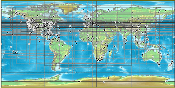
A map generated by Metacat’s GeoServer. Points and “bounding boxes” represent the geographic extent of datasets stored in the KNB Metacat repository.
GeoServer supports a wide variety of vector GIS data sources, which can be styled using Styled Layer Descriptors (SLDs) and output as images (the default) or raw vector data (GML or KML).
Currently, GeoServer can be used with the following limitations:
- GeoServer will only map documents that are publicly available. This is because the mapping server’s support for permissions control is not as fine-grained as Metacat’s.
Metacat developers plan to continue extending and improving Metacat’s mapping capabilities. If you are interested in contributing to those efforts, or if you are interested in learning more about the architecture and future plans for the mapping software, please contact the Metacat development team (metacat-dev@ecoinformatics.org).
11.1. Installing and Configuring
The GeoServer webapp should be installed as a sibling of Metacat. If you do NOT wish to run GeoServer, the deployment can be skipped, but any skins that use maps will not render correctly. (NOTE: Geoserver recommends using a PermGen space setting of at least 128MB.).
Metacat comes with a pre-configured data directory to be used by GeoServer. This includes a world-countries base layer and a default configuration that is already aware of Metacat’s spatial cache. The Metacat configuration interface is used to configure GeoServer to use this shared data directory. To further configure GeoServer, use the Web-based configuration utility, which is available at: http://your.server.com/<geoserver_context> (e.g., http://knb.ecoinformatics.org/geoserver).
Common configuration tasks include:
- Adding a Map to a Web Page or Skin
- Configuring the Size and Initial Extent of the Map
- Configuring the Layout of the HTML Mapping Interface
- Configuring the “Select Location Drop-down Menu
- Configuring the Visual Portrayal of Geospatial Data (e.g., symbology and color)
- Adding Other Spatial Datasets to the Web Map
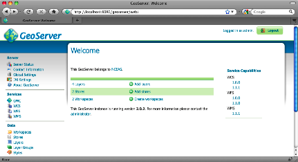
GeoServer’s Web-based administrative interface.
Note: Some configurations may need to be made to the XML files as well.
OpenLayers, which Metacat uses as the front-end for GeoServer’s WMS service, provides interface components or “widgets” (e.g., the map, a box zoom, layer list, “Select Location” drop-down menu, scale bar, lat/long coordinates, and a query form) that make it easy to deploy web-based mapping applications with minimal coding.
OpenLayers has three main configuration files used to customize the map interface. Default configurations are in:
$METACAT/lib/style/common/spatial/
| Document | Location | Description |
|---|---|---|
| The named location file | locations.jsp | The list of pre-defined locations (name and lat/lon bounds) |
| Main map rendering functions | maps.js | Defines the map, widgets and their behavior |
| The rendered map and page layout | map.jsp | Loads the map and controls the HTML layout of the widgets. |
NOTE: By default, the first time Metacat is restarted, it generates a “spatial cache” containing geographic information about documents in its repository. This default behavior is specified in lib/metacat.properties, where the regenerateCacheOnRestart parameter is set to true. The information in the spatial cache is stored in a GIS-compatible format (the ESRI Shapefile) and consists of the document name and its geographic coverage. When documents are inserted, deleted, and updated in the Metacat repository, Metacat automatically syncs the spatial cache to reflect the changes. Because generating the cache can take a considerable amount of time (several minutes in the case of a few thousand documents), Metacat resets the regenerateCacheOnRestart property to false after the spatial cache has been generated. Note that if you upgrade or reinstall Metacat, the spatial cache will be regenerated again.
11.1.1. Adding a Map to a Web Page or Skin
To add a map to a Web page, simply include the map interface using an iframe:
<iframe scrolling="no" frameborder="0" width="780" height="420"
        src="/metacat/style/common/spatial/map.jsp">
</iframe>
The map URL, /metacat/style/common/spatial/map.jsp, is
the default map interface. If you plan to customize the map interface, copy
the map.jsp file into your skin’s directory (either the default or
customized skin directory).
cp -r style/common/spatial/map.jsp /style/skins/<myskin>/spatial
You can access the customized map with the URL: /metacat/style/skins/<myskin>/spatial/map.jsp
11.1.2. Configuring the Size and Initial Extent of the Map
Before you configure the size and initial extent of the map, make sure that you
have copied the map layout page into your skin’s directory (See
Configuring Metacat for directions). Once the file has been copied, you can
modify the map’s initial extent in: ${skin.dir}/spatial/map.jsp.
To change the map’s initial extent, edit the bounding box. The default is to
show the entire globe. The initMap() function should also be given the skin
name so that spatial search results can be correctly styled.
<script type="text/javascript">
    function init() {
       var bounds = new OpenLayers.Bounds(-180,-90,180,90);
       // make the map for this skin
       initMap("<%=GEOSERVER_URL%>", "<%=SERVLET_URL%>", "default", bounds);
    }
</script>
The size (height/width) of the map can be controlled by the #map CSS entry
included in the map.jsp page.
11.1.3. Configuring the Layout of the HTML Mapping Interface
The size and initial extent of the map can be edited in : ${skin.dir}/spatial/map.jsp.
The map.jsp is a simple container that can be included in other more complex pages if desired. It contains the map, widgets and location dropdown list.
11.1.5. Configuring the Visual Portrayal of Geospatial Data (e.g., symbology and color)
Geospatial data sets are styled through the use of Styled Layer Descriptors
(SLD). The default SLDs used for the data points and data bounding boxes are in
/lib/spatial/geoserver/data/styles/ and are named data_points_style.sld and
data_bounds_style.sld, respectively.
You can find a more detailed tutorial on using SLD with GeoServer in the GeoServer documentation:
http://docs.geoserver.org/
11.1.6. Adding Other Spatial Datasets to the Web Map
If you have vector GIS data sets, such as weather or topographical information, on your server that you’d like to include in the interactive map, you must first register the data set with GeoServer. After the data set has been registered, you can add the layer to the map. You can also add spatial layers that have been made publically available through WMS (There are hundreds of spatial data sets available. Check out wms-sites.com for good catalog). Instructions for adding publically available layers are included at the end of this section.
To register the data set and add it to the map:
- Point your browser to
http://your.server/geoserver, log in to GeoServer, and navigate to the “Data Stores” configuration page underData > Stores. - Create a new vector data source from a Shapefile in the “metacat” workspace.
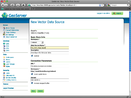
Creating a new shapefile using GeoServers web-based administrative interface.
- The Description, if specified, is mostly used internally to provide other administrators with information about the DataStore. Click Submit.
- Navigate to the “Layers” configuration page under Data > Layers. Add a new Layer from your new data source.
- You should also define a spatial reference system (SRS) number for the new layer. Most lat/long data is “4326”. If your data is in another projection, determine its spatial reference system using the help links provided.
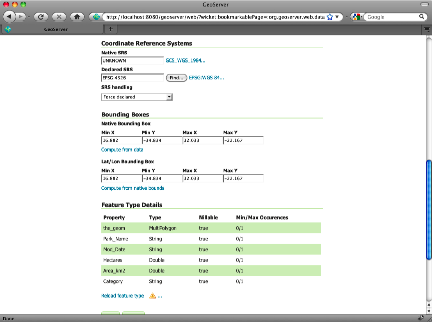
GeoServer’s FeatureType configuration. The SRS settings discussed in step 5 are highlighted.
- Style the layer using a style from the drop-down menu on the Publishing tab, or create a new SLD to create a new style object and corresponding SLD (this option provides more control over the style).
- Try out the styled data set as a WMS layer using a the Layer Preview.
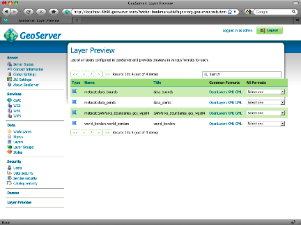
GeoServer’s Layer Preview allows you to see an OpenLayer rendering of the new layer.
- Copy the default
map.jsfile that assembles the map in OpenLayers (style/common/spatial/map.js) to your skin’s spatial directory. - Edit the init() method to include your new layer in the map - either as an overlay or as a base layer.
- Point your browser to the map interface. Your new layer should appear with the existing ones.
11.1.7. Adding External Spatial Data Made Publically Available through WMS
There are hundreds of sources of spatial data made publically available
through WMS (check out http://wms-sites.com for a good catalog). To add these
data sources to your map, add the layers in your skin’s spatial/map.js file.
11.2. Spatial Queries
To find out which documents in the Metacat repository lie in a specified geographic region, query the spatial cache using Metacat’s spatial_query action. Metacat can perform any query supported by the WFS/WMS standards.
An example of a spatial query string is:
http://localhost/metacat/metacat?action=spatial_query&xmin=-117.5&xmax=-64&ymin=3&ymax=46&skin=default
Where xmin, xmax, ymin and ymax represent the western, eastern,
southern and northern bounding coordinates (the “bounding box”), respectively.
The spatial query action returns all documents that overlap or that are
contained inside the specified spatial coordinates. The result set is returned
as HTML using the style of the specified skin (in this example, default).